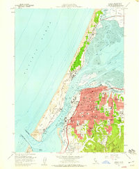
1958 Map of Eureka
USGS Topo · Published 1959About this map
Fort Humboldt State Historical Monument stands as a landmark overlooking Bucksport and the inner reaches of Arcata Bay, anchoring the southern edge of a growing Eureka urban core. The city is detailed down to its neighborhood street grids, featuring numerous educational institutions such as Lincoln School, Washington School, and the Junior High School. To the west, the Samoa Peninsula creates a barrier of Sand Dunes between the Pacific Ocean and the bay, sheltering the maritime industrial settlements of Samoa, Manila, and Fairhaven. The transit network is dominated by the Northwestern Pacific Railroad and the Redwood Highway, which facilitate movement between the shoreline and the timbered hills near Cutten and Rosewood. Notable islands like Gunther Island and Woodley Island break the waters of the bay, marking the complex tidal environment of the Mad River Slough.
Find a feature on this map
59 named features on this map. Tap any name to fly to it.
Don’t see what you’re looking for? This feature index may not catch every label — zoom into the map to look around manually.
Map Details
Editions of this 1958 Eureka Map
3 editions found
Other maps of this area

1916 · Cape Fortunas
USGS Topo · 1:62,500

1922 · Eureka
USGS Topo · 1:62,500

1933 · Eureka
USGS Topo · 1:48,000

1942 · Eureka
USGS Topo · 1:62,500

1943 · Ferndale
USGS Topo · 1:62,500

1944 · Fortuna
USGS Topo · 1:62,500

1949 · Eureka
USGS Topo · 1:250,000

1951 · Eureka
USGS Topo · 1:62,500

1951 · Ferndale
USGS Topo · 1:62,500
1952 · Arcata North
USGS Topo · 1:24,000