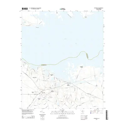
2014 Map of Eutawville
USGS Topo · Published 2014About this map
Eutawville serves as a central hub on this South Carolina landscape, where the terrestrial settlements of Green Town, Possum Town, and Little Belvidere meet the expansive waters of Lake Marion. The map illustrates a complex shoreline north of Eutaw Springs, featuring prominent landforms like Pine Island, Goat Island, and Round Island that define the modern character of the Upper Santee region. Inland, the grid of Old Number Six Hwy and Roosevelt Dr connects established local centers with several historic burial grounds, including Walworth Cem, Walnut Grove Cem, and Eutawville Cem. The presence of Ferguson Landing and several island-bound trails like Hundred Acre Island Trail suggests a community deeply integrated with the lake's geography, balancing residential growth in places like Saint Julian with the legacy of older rural crossroads.
Find a feature on this map
83 named features on this map. Tap any name to fly to it.
Don’t see what you’re looking for? This feature index may not catch every label — zoom into the map to look around manually.
Map Details
Editions of this 2014 Eutawville Map
This is the sole edition of this map. No revisions or reprints were ever made.
Other maps of this area

1920 · Eutawville
USGS Topo · 1:48,000

1920 · Chicora
USGS Topo · 1:48,000

1920 · Manning
USGS Topo · 1:48,000

1921 · Chicora
USGS Topo · 1:62,500

1921 · Manning
USGS Topo · 1:62,500

1921 · Eutawville
USGS Topo · 1:62,500

1943 · Chicora
USGS Topo · 1:62,500

1943 · Eutawville
USGS Topo · 1:62,500

1944 · Manning
USGS Topo · 1:62,500

1954 · Augusta
USGS Topo · 1:250,000