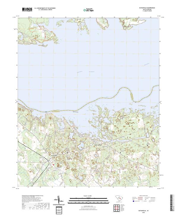
2024 Map of Eutawville
USGS Topo · Published 2024About this map
Lake Marion and the Santee River define the northern expanse of this landscape, where the waters of the Santee basin meet the established settlements of Orangeburg County. The community of Eutawville serves as a central hub, with its surrounding residential patterns extending toward Eutaw Springs and the historic crossing at Nelsons Ferry. The map details a transition from the protected wetlands of the Santee National Wildlife Refuge, including Goat Island and Round Island, to the agricultural and timber lands of the interior. Genealogists can identify several distinct burial sites, including Eutawville Cem, the Silas Church Graveyard, and Walnut Grove Cem. Local infrastructure is marked by a network of rural routes such as Moncks Corner Rd and Nelson Ferry Rd, illustrating how the modern road system follows the historical paths between the river and the inland farms.
Find a feature on this map
93 named features on this map. Tap any name to fly to it.
Don’t see what you’re looking for? This feature index may not catch every label — zoom into the map to look around manually.
Map Details
Editions of this 2024 Eutawville Map
This is the sole edition of this map. No revisions or reprints were ever made.
Historical Maps of Possum Town Through Time
5 maps found