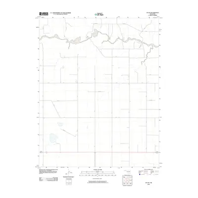
2010 Map of Eva SE
USGS Topo · Published 2010About this map
Goff Creek meanders through the northern plains of the Oklahoma Panhandle, providing a rare riparian break in a landscape otherwise defined by a rigid section-line road grid. This part of Texas County is characterized by large agricultural tracts and a meticulous network of rural routes, including Road N and N0850 Rd, which connect the scattered homesteads of the area. The map reveals the systematic development of the High Plains, where the drainage of the creek and small isolated depressions are the only interruptions to the geometric regularity of the surveyed land. While no major towns are situated here, the presence of these thoroughfares like E0095 Rd and E0140 Rd underscores the organized agrarian economy and movement patterns of the early twenty-first century.
Find a feature on this map
18 named features on this map. Tap any name to fly to it.
Don’t see what you’re looking for? This feature index may not catch every label — zoom into the map to look around manually.
Map Details
Editions of this 2010 Eva SE Map
This is the sole edition of this map. No revisions or reprints were ever made.
Other maps of this area

1954 · Perryton
USGS Topo · 1:250,000

1958 · Perryton
USGS Topo · 1:250,000

1973 · Texhoma NE
USGS Topo · 1:24,000

1973 · Goodwell NW
USGS Topo · 1:24,000
1973 · Elkhart South
USGS Topo · 1:24,000

1973 · Eva SE
USGS Topo · 1:24,000

1973 · Hough SW
USGS Topo · 1:24,000
1973 · Texhoma NW
USGS Topo · 1:24,000
1973 · Eva
USGS Topo · 1:24,000

1973 · Hough NW
USGS Topo · 1:24,000