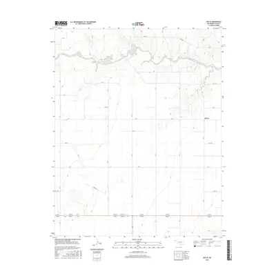
2016 Map of Eva SE
USGS Topo · Published 2016About this map
The settlement of Muncy serves as the focal point of this rural landscape in the Oklahoma Panhandle, situated within a grid of section-line roads. The terrain is defined by the winding course of Goff Creek, which carves a distinct corridor through the plains as it flows across the northern portion of the map. This drainage system provides the primary relief in an otherwise flat agricultural expanse, marked by a systematic network of thoroughfares including Road N and E0125 Rd. The map illustrates the persistent structure of high-plains land division, where long straight roads like N0650 Rd and E0135 Rd connect isolated farmsteads and agricultural operations. This 2016 survey captures the modern state of Texas County's rural infrastructure, maintaining a pattern of settlement and transportation that has anchored the region for over a century.
Find a feature on this map
26 named features on this map. Tap any name to fly to it.
Don’t see what you’re looking for? This feature index may not catch every label — zoom into the map to look around manually.
Map Details
Editions of this 2016 Eva SE Map
This is the sole edition of this map. No revisions or reprints were ever made.
Other maps of this area

1954 · Perryton
USGS Topo · 1:250,000

1958 · Perryton
USGS Topo · 1:250,000

1973 · Texhoma NE
USGS Topo · 1:24,000

1973 · Goodwell NW
USGS Topo · 1:24,000
1973 · Elkhart South
USGS Topo · 1:24,000

1973 · Eva SE
USGS Topo · 1:24,000

1973 · Hough SW
USGS Topo · 1:24,000
1973 · Texhoma NW
USGS Topo · 1:24,000
1973 · Eva
USGS Topo · 1:24,000

1973 · Hough NW
USGS Topo · 1:24,000