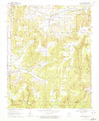
1970 Map of Evansville
USGS Topo · Published 1972About this map
The borderlands of Northwest Arkansas and Oklahoma are defined here by a series of steep ridges and hollows, where the Boston mountains meet the edge of the Ozarks. Small agricultural communities like Dutch Mills, Morrow, and Evansville are situated along the winding paths of Evansville Creek and Baron Fk, reflecting a settlement pattern deeply tied to the narrow valley floors. The map reveals an extensive network of family and community burial grounds, such as Vineyard Cem and Academy Cem, which serve as vital markers for genealogical research in this rural pocket of Washington County.
Find a feature on this map
46 named features on this map. Tap any name to fly to it.
Don’t see what you’re looking for? This feature index may not catch every label — zoom into the map to look around manually.
Map Details
Editions of this 1970 Evansville Map
3 editions found
Other maps of this area

1898 · Winslow #3
USGS Topo · 1:62,500

1898 · Tahlequah
USGS Topo · 1:125,000

1898 · Winslow
USGS Topo · 1:125,000

1901 · Winslow
USGS Topo · 1:125,000

1901 · Tahlequah
USGS Topo · 1:125,000

1905 · Tahlequah
USGS Topo · 1:125,000

1946 · Fort Smith
USGS Topo · 1:250,000

1965 · Fort Smith
USGS Topo · 1:250,000

1967 · Fort Smith
USGS Topo · 1:250,000

1969 · Natural Dam
USGS Topo · 1:24,000