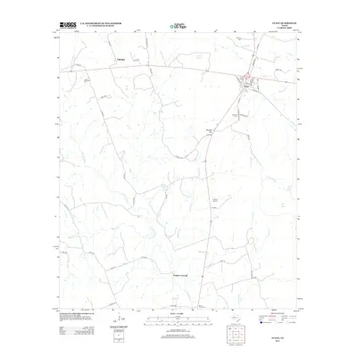
2012 Map of Evant
USGS Topo · Published 2012About this map
The town of Evant serves as the primary hub of this Central Texas landscape, situated at a major crossroads where the residential street grid includes names like Tom Sawyer St and Wurts. The Lampasas River meanders across the territory, defining the drainage patterns for numerous seasonal waterways such as Bennett Cr and Freeman Br. For family historians, the sheet is particularly dense with burial sites including Murphy Cem, Kingsbury Cem, and Hines Chapel Cem, which are scattered among the agricultural holdings and ranch lands. To the west, the small settlement of Fairview anchors a network of county roads. The terrain is marked by distinctive hydrological features like Beef Pen Spring and Brooks Spring, while the passage through Gholson Gap provides a clear landmark in the local topography near the community of Gholson.
Find a feature on this map
57 named features on this map. Tap any name to fly to it.
Don’t see what you’re looking for? This feature index may not catch every label — zoom into the map to look around manually.
Map Details
Editions of this 2012 Evant Map
This is the sole edition of this map. No revisions or reprints were ever made.
Other maps of this area

1887 · Lampasas
USGS Topo · 1:125,000

1888 · Hamilton
USGS Topo · 1:125,000

1894 · Hamilton
USGS Topo · 1:125,000

1894 · Lampasas
USGS Topo · 1:125,000

1954 · Brownwood
USGS Topo · 1:250,000

1954 · Evant
USGS Topo · 1:62,500

1954 · Evant
USGS Topo · 1:24,000
1954 · Izoro
USGS Topo · 1:24,000
1954 · Pearl
USGS Topo · 1:24,000
1954 · Adamsville
USGS Topo · 1:24,000