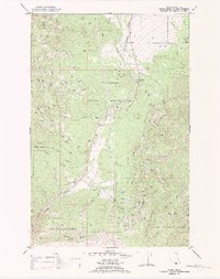
1989 Map of Evaro
USGS Topo · Published 1989About this map
Flathead Indian Reservation lands meet the northern reaches of the Lolo National Forest in this 1989 study of the Montana landscape. The Burlington Northern railroad serves as a central artery through the corridor, passing the small settlements of Schley and Evaro. The terrain is defined by dramatic elevation changes, rising from the valley floors of Finley Creek and O'Keefe Creek up toward the high point of TV Mountain, which is marked by prominent Radio Towers.
Find a feature on this map
23 named features on this map. Tap any name to fly to it.
Don’t see what you’re looking for? This feature index may not catch every label — zoom into the map to look around manually.
Map Details
Editions of this 1989 Evaro Map
This is the sole edition of this map. No revisions or reprints were ever made.
Other maps of this area

1903 · Bonner
USGS Topo · 1:125,000

1912 · Missoula
USGS Topo · 1:125,000

1921 · Elbow Lake
USGS Topo · 1:125,000

1947 · Butte
USGS Topo · 1:250,000

1955 · Choteau
USGS Topo · 1:250,000

1956 · Wallace
USGS Topo · 1:250,000

1956 · Hamilton
USGS Topo · 1:250,000

1957 · Choteau
USGS Topo · 1:250,000

1958 · Butte
USGS Topo · 1:250,000

1958 · Choteau
USGS Topo · 1:250,000