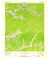
1954 Map of Evarts
USGS Topo · Published 1955About this map
The Louisville and Nashville railroad follows the winding banks of the Clover Fork and Yocum Creek in this mid-1950s survey of the Harlan County coalfields. Industrial activity is evident throughout the valley, from the presence of Strip Mines on the ridges to local operations like Draper and Pounding Mill. Small company towns and residential clusters such as Evarts, Kenvir, and Kildav are closely tied to these transport and extraction corridors.
Find a feature on this map
81 named features on this map. Tap any name to fly to it.
Don’t see what you’re looking for? This feature index may not catch every label — zoom into the map to look around manually.
Map Details
Editions of this 1954 Evarts Map
3 editions found
Other maps of this area

1887 · Jonesville
USGS Topo · 1:125,000

1891 · Jonesville
USGS Topo · 1:125,000

1903 · Harlan
USGS Topo · 1:48,000

1916 · Harlan
USGS Topo · 1:48,000

1916 · Nolansburg
USGS Topo · 1:48,000

1919 · Nolansburg
USGS Topo · 1:62,500

1919 · Harlan
USGS Topo · 1:62,500

1932 · Hagan
USGS Topo · 1:62,500

1935 · Hubbard Springs
USGS Topo · 1:24,000
1935 · Evarts
USGS Topo · 1:24,000