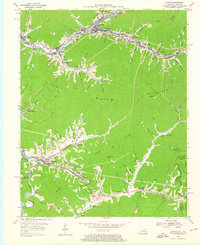
1954 Map of Evarts
USGS Topo · Published 1967About this map
Clover Fork and Yocum Creek dictate the settlement patterns of this Harlan County region in the mid-1950s, where coal-related infrastructure and small mining communities are etched into the valleys. The town of Evarts serves as a central hub, while the Louisville and Nashville railroad tracks follow the river bends to service industrial points like Kenvir and Black Mountain. The landscape is characterized by its steep relief, with Little Black Mountain and Lone Spur rising sharply above the winding creek-side settlements.
Find a feature on this map
105 named features on this map. Tap any name to fly to it.
Don’t see what you’re looking for? This feature index may not catch every label — zoom into the map to look around manually.
Map Details
Editions of this 1954 Evarts Map
3 editions found
Other maps of this area

1887 · Jonesville
USGS Topo · 1:125,000

1891 · Jonesville
USGS Topo · 1:125,000

1903 · Harlan
USGS Topo · 1:48,000

1916 · Harlan
USGS Topo · 1:48,000

1916 · Nolansburg
USGS Topo · 1:48,000

1919 · Nolansburg
USGS Topo · 1:62,500

1919 · Harlan
USGS Topo · 1:62,500

1932 · Hagan
USGS Topo · 1:62,500

1935 · Hubbard Springs
USGS Topo · 1:24,000
1935 · Evarts
USGS Topo · 1:24,000