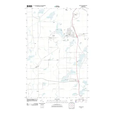
2010 Map of Eveleth
USGS Topo · Published 2010About this map
Leonidas Mine and Virginia Mine define the industrial landscape of the Mesabi Range in this detailed view. The city of Eveleth serves as the hub of activity, surrounded by an extensive network of iron extraction sites including the Hull-Nelson Mine, Adams Pit, and Fayal Pit. This period of the early 21st century shows the established footprint of the iron industry alongside recreational and civic landmarks. Further south, the landscape shifts toward a high density of water bodies like Saint Marys Lake and Long Lake, where Kalleva Island sits. Smaller settlements and rail junctions such as Leonidas, Ramshaw, and Iron Junction highlight the historical importance of the transportation network that moved ore from the pits to the ports. Genealogists can locate specific civic structures like the Eveleth Post Office and Iron Post Office, while outdoor history is preserved at Camp Warren and Camp Olcott.
Find a feature on this map
94 named features on this map. Tap any name to fly to it.
Don’t see what you’re looking for? This feature index may not catch every label — zoom into the map to look around manually.
Map Details
Editions of this 2010 Eveleth Map
This is the sole edition of this map. No revisions or reprints were ever made.
Other maps of this area

1950 · Mc Kinley
USGS Topo · 1:24,000

1951 · Mc Kinley
USGS Topo · 1:24,000

1951 · Gilbert
USGS Topo · 1:24,000

1951 · Eveleth
USGS Topo · 1:24,000

1951 · Virginia
USGS Topo · 1:24,000

1951 · Kinney
USGS Topo · 1:24,000

1951 · Kirk
USGS Topo · 1:24,000

1951 · Central Lakes
USGS Topo · 1:24,000

1951 · Zim
USGS Topo · 1:24,000

1951 · Casco
USGS Topo · 1:24,000