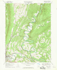
1968 Map of Everett East
USGS Topo · Published 1970About this map
The Raystown Branch Junata River carves a dramatic, winding path through the center of this 1968 study, defining the landscape of central Bedford County. To the west, the borough of Everett serves as a primary hub of activity, featuring the Everett-Southern High Sch, the Everett Cemetery, and a Radio Station (WSKE). The southern edge is dominated by the corridor of the Pennsylvania Turnpike, linking the community of Earlston to the traveler stop at Breezewood in the southeast corner.
Find a feature on this map
53 named features on this map. Tap any name to fly to it.
Don’t see what you’re looking for? This feature index may not catch every label — zoom into the map to look around manually.
Map Details
Editions of this 1968 Everett East Map
4 editions found
Other maps of this area

1900 · Everett
USGS Topo · 1:62,500

1902 · Everett
USGS Topo · 1:62,500

1925 · Needmore
USGS Topo · 1:48,000

1927 · Clearville
USGS Topo · 1:48,000

1930 · Broad Top
USGS Topo · 1:62,500

1931 · Clearville
USGS Topo · 1:62,500

1933 · Broad Top
USGS Topo · 1:62,500

1935 · Needmore
USGS Topo · 1:62,500

1939 · Needmore
USGS Topo · 1:62,500

1944 · Clearville
USGS Topo · 1:62,500
Featured Places
- Everett, PA
- West Providence Township, PA
- Tatesville, Hopewell Township
- East Providence Township, PA
- Cypher Beach, Broad Top Township