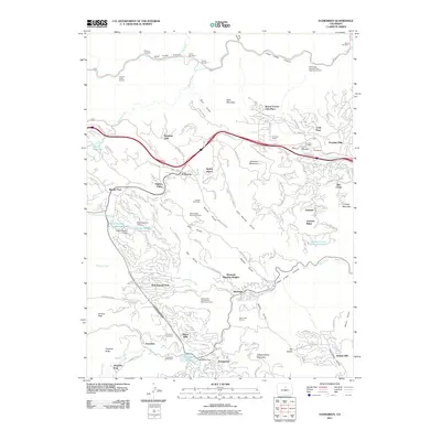
2011 Map of Evergreen
USGS Topo · Published 2011About this map
Evergreen sits at the heart of this mountain landscape, where the waters of Bear Creek flow into Evergreen Lake, held by the Evergreen Dam. The settlement pattern reflects a mid-century expansion into the foothills, with residential clusters like Hiwan Hills, Wah Keeney Park, and Mountain Meadow Heights branching out from the historic core. This 2011 survey reveals the area's transition from a mining-oriented past to a residential and recreational hub. Traces of earlier industry remain visible through geological features such as the Sunrise Peak Mine and the Roscoe Beryl Quarry, alongside the Seven Hills-Yetter Ranch Pegmatite Quarry. Further north, the steep walls of Clear Creek Canyon are bypassed by a series of tunnels, including Tunnel Number 3, while community anchors such as Evergreen Cemetery and Rockland Cemetery provide critical points of interest for local genealogy and history.
Find a feature on this map
118 named features on this map. Tap any name to fly to it.
Don’t see what you’re looking for? This feature index may not catch every label — zoom into the map to look around manually.
Map Details
Editions of this 2011 Evergreen Map
This is the sole edition of this map. No revisions or reprints were ever made.
Other maps of this area

1899 · West Denver
USGS Topo · 1:125,000

1906 · Blackhawk
USGS Topo · 1:62,500

1938 · Morrison
USGS Topo · 1:24,000

1939 · Golden
USGS Topo · 1:24,000

1942 · Morrison
USGS Topo · 1:31,680

1942 · Golden
USGS Topo · 1:31,680

1942 · Black Hawk
USGS Topo · 1:24,000

1942 · Ralston Buttes
USGS Topo · 1:24,000

1944 · Black Hawk
USGS Topo · 1:31,680
1944 · Ralston Buttes
USGS Topo · 1:31,680