
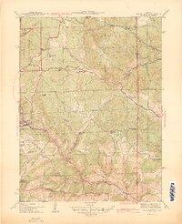
1944 Map of Black Hawk
USGS Topo · Published 1944About this map
Central City and Black Hawk serve as the focal points of this 1940s survey, illustrating the concentrated mining and civic infrastructure of the Front Range. The landscape is defined by the steep drainage of the North Fork Clear Creek and an intricate network of gulches that tell the story of Colorado's lode mining legacy. Evidence of early industry and community life appears in sites like the Summit Mine and the Bay State Sch, while the rugged verticality is marked by named peaks such as Tremont Mtn and Justice Hill.
Find a feature on this map
39 named features on this map. Tap any name to fly to it.
Don’t see what you’re looking for? This feature index may not catch every label — zoom into the map to look around manually.
Map Details
Editions of this 1944 Black Hawk Map
2 editions found
Other maps of this area

1899 · West Denver
USGS Topo · 1:125,000

1903 · Georgetown
USGS Topo · 1:62,500

1905 · Central City
USGS Topo · 1:62,500

1905 · Georgetown
USGS Topo · 1:62,500

1906 · Blackhawk
USGS Topo · 1:62,500

1910 · Central City
USGS Topo · 1:62,500

1912 · Central City
USGS Topo · 1:62,500

1942 · Eldorado Springs
USGS Topo · 1:24,000

1942 · Nederland
USGS Topo · 1:24,000

1942 · Central City
USGS Topo · 1:24,000