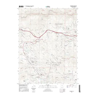
2016 Map of Evergreen
USGS Topo · Published 2016About this map
Evergreen serves as the focal point of this Front Range landscape, where the confluence of Bear Creek and Wilmot Creek feeds into Evergreen Lake. The settlement pattern follows the winding drainages and ridgelines of the foothills, with established communities like Bergen Park, Kittredge, and Indian Hills connected by the prominent Evergreen Parkway. This 2016 survey documents a complex network of residential developments such as Hiwan Hills and Hidden Valley alongside institutional landmarks like the Mount Vernon Institute and Wah Keeney Park School.
Find a feature on this map
68 named features on this map. Tap any name to fly to it.
Don’t see what you’re looking for? This feature index may not catch every label — zoom into the map to look around manually.
Map Details
Editions of this 2016 Evergreen Map
This is the sole edition of this map. No revisions or reprints were ever made.
Other maps of this area

1899 · West Denver
USGS Topo · 1:125,000

1906 · Blackhawk
USGS Topo · 1:62,500

1938 · Morrison
USGS Topo · 1:24,000

1939 · Golden
USGS Topo · 1:24,000

1942 · Morrison
USGS Topo · 1:31,680

1942 · Golden
USGS Topo · 1:31,680

1942 · Black Hawk
USGS Topo · 1:24,000

1942 · Ralston Buttes
USGS Topo · 1:24,000

1944 · Black Hawk
USGS Topo · 1:31,680
1944 · Ralston Buttes
USGS Topo · 1:31,680