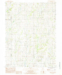
1984 Map of Eversonville
USGS Topo · Published 1985About this map
Eversonville stands as a central point in this rural landscape near the intersection of Livingston and Linn counties. The area is defined by a dense network of meandering waterways, including the winding course of Muddy Creek and its tributary, Little Muddy Creek, which cut through the agricultural terrain. Small, dispersed settlements like Shafter in the north and Hecla in the center point to a history of small-town community hubs that supported the surrounding farmsteads.
Find a feature on this map
19 named features on this map. Tap any name to fly to it.
Don’t see what you’re looking for? This feature index may not catch every label — zoom into the map to look around manually.
Map Details
Editions of this 1984 Eversonville Map
This is the sole edition of this map. No revisions or reprints were ever made.
Other maps of this area

1924 · Chula
USGS Topo · 1:62,500

1946 · Brookfield
USGS Topo · 1:62,500

1946 · Galt
USGS Topo · 1:62,500

1947 · Chula
USGS Topo · 1:62,500

1948 · Brookfield
USGS Topo · 1:62,500

1949 · Galt
USGS Topo · 1:62,500

1953 · Moberly
USGS Topo · 1:250,000

1954 · Centerville
USGS Topo · 1:250,000

1954 · Moberly
USGS Topo · 1:250,000

1957 · Moberly
USGS Topo · 1:250,000