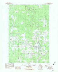
1982 Map of Ewen
USGS Topo · Published 1983About this map
Ewen serves as the central hub of this Upper Peninsula landscape, situated where the South Branch Ontonagon River winds through the southern reaches of the Ottawa National Forest. The map documents a transition from the forested wetlands of the north to the agricultural and residential pockets around the town site. An Old RR Grade cuts across the terrain, tracing the path of the region's earlier timber and mining transport network. Local landmarks such as the Ewen Pines Roadside Park and the Cem northeast of town provide specific points of interest for genealogists and local historians. To the southeast, the small settlement of Kostlenick sits near the namesake Kostlenick Creek, while the presence of a Gravel Pit and a Gas Pipeline reflect the mid-century industrial utility of the Ontonagon and Gogebic county borderlands.
Find a feature on this map
26 named features on this map. Tap any name to fly to it.
Don’t see what you’re looking for? This feature index may not catch every label — zoom into the map to look around manually.
Map Details
Editions of this 1982 Ewen Map
This is the sole edition of this map. No revisions or reprints were ever made.
Other maps of this area

1949 · Matchwood NW
USGS Topo · 1:24,000

1949 · Rockland
USGS Topo · 1:62,500

1951 · Rockland
USGS Topo · 1:62,500

1952 · Watersmeet
USGS Topo · 1:62,500

1952 · Thayer
USGS Topo · 1:62,500

1956 · Matchwood NW
USGS Topo · 1:24,000

1956 · Matchwood
USGS Topo · 1:62,500

1958 · Iron River
USGS Topo · 1:250,000

1960 · Iron River
USGS Topo · 1:250,000

1961 · Iron River
USGS Topo · 1:250,000