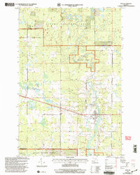
1999 Map of Ewen
USGS Topo · Published 2004About this map
The settlement of Ewen serves as the central hub of this late-twentieth-century landscape, positioned near the crossing of the Ontonagon River. The township's infrastructure is clearly defined by local thoroughfares such as Airport Road, Cemetery Road, and Choate Road, providing access to rural homesteads and agricultural plots. Much of the surrounding terrain is managed as part of the Ottawa National Forest, where the Ontonagon River meanders toward the Flannigan Rapids. Along the riverbanks, specialized features like the Canoe Access and the Roadside Park indicate the area's value for recreation and transit. Local genealogy is anchored by the Cem located east of town, while the presence of a Sewage Lagoon and various Gravel Pit sites reflect the municipal and industrial footprint of the community at the turn of the millennium.
Find a feature on this map
25 named features on this map. Tap any name to fly to it.
Don’t see what you’re looking for? This feature index may not catch every label — zoom into the map to look around manually.
Map Details
Editions of this 1999 Ewen Map
This is the sole edition of this map. No revisions or reprints were ever made.
Other maps of this area

1949 · Matchwood NW
USGS Topo · 1:24,000

1949 · Rockland
USGS Topo · 1:62,500

1951 · Rockland
USGS Topo · 1:62,500

1952 · Watersmeet
USGS Topo · 1:62,500

1952 · Thayer
USGS Topo · 1:62,500

1956 · Matchwood NW
USGS Topo · 1:24,000

1956 · Matchwood
USGS Topo · 1:62,500

1958 · Iron River
USGS Topo · 1:250,000

1960 · Iron River
USGS Topo · 1:250,000

1961 · Iron River
USGS Topo · 1:250,000