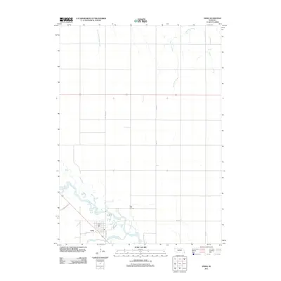
2011 Map of Ewing
USGS Topo · Published 2011About this map
Ewing serves as the focal point of this Holt County landscape, positioned where the Elkhorn River and the South Fork Elkhorn River converge. The settlement's infrastructure is anchored by the Ewing Post Office and connected to the surrounding countryside via routes like State Hwy L 45B and Thramer Rolling Hl. To the north, the terrain is defined by the drainage of South Branch Verdigre Creek and Big Springs Creek, illustrating the importance of water systems to the region's layout. Local history and genealogy interests are centered at Saint Peter Cemetery, located just north of the river fork. This 2011 survey captures the town's enduring relationship with the river valley, showing a network of rural roads such as 512th Ave and 858th Rd that reach out into the Nebraska prairie.
Find a feature on this map
14 named features on this map. Tap any name to fly to it.
Don’t see what you’re looking for? This feature index may not catch every label — zoom into the map to look around manually.
Map Details
Editions of this 2011 Ewing Map
This is the sole edition of this map. No revisions or reprints were ever made.
Other maps of this area

1955 · O'Neill
USGS Topo · 1:250,000

1958 · Page
USGS Topo · 1:24,000

1959 · O'Neill
USGS Topo · 1:250,000

1963 · Ewing SW
USGS Topo · 1:24,000

1963 · Venus
USGS Topo · 1:24,000

1963 · Orchard
USGS Topo · 1:24,000

1963 · Ewing
USGS Topo · 1:24,000

1963 · Deloit NE
USGS Topo · 1:24,000
1963 · Clearwater
USGS Topo · 1:24,000

1963 · Deloit NW
USGS Topo · 1:24,000