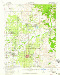
1952 Map of Exeter
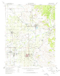
USGS Topo · Published 1959About this map
Exeter and the surrounding Tulare County agricultural corridor are captured here during a period of significant irrigation development. The landscape is defined by an intricate network of water management, featuring the Friant Kern Canal, St Johns River, and Kaweah River feeding numerous ditches like Peoples Ditch and Wutchumna Ditch. This infrastructure supported established citrus and fruit-growing communities such as Lemoncove, Ivanhoe, and Woodlake.
Find a feature on this map
151 named features on this map. Tap any name to fly to it.
Don’t see what you’re looking for? This feature index may not catch every label — zoom into the map to look around manually.
Map Details
Editions of this 1952 Exeter Map
2 editions found
Other maps of this area

1903 · Tehipite
USGS Topo · 1:125,000

1904 · Kaweah
USGS Topo · 1:125,000

1905 · Tehipite
USGS Topo · 1:125,000

1909 · Kaweah
USGS Topo · 1:125,000

1921 · Stokes Mountain
USGS Topo · 1:24,000

1922 · Trimmer
USGS Topo · 1:96,000

1923 · Sultana
USGS Topo · 1:31,680

1924 · Dinuba
USGS Topo · 1:125,000

1924 · Stokes Mountain
USGS Topo · 1:31,680

1925 · Rocky Hill
USGS Topo · 1:31,680