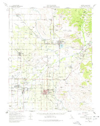
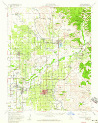
1952 Map of Exeter
USGS Topo · Published 1978About this map
The citrus-growing heart of the Central Valley unfolds across this mid-century survey, anchored by the hub of Exeter. The landscape is defined by an intricate network of irrigation, including the Friant-Kern Canal and the Wutchumna Ditch, which redirect water from the Kaweah River and St Johns River to orchards. The era's transportation is dominated by three competing rail lines—the Atchison Topeka And Santa Fe, Southern Pacific, and the Visalia Electric—which connected smaller packing points like Hillmaid, Lemoncove, and Naranjo to the larger market.
Find a feature on this map
154 named features on this map. Tap any name to fly to it.
Don’t see what you’re looking for? This feature index may not catch every label — zoom into the map to look around manually.
Map Details
Editions of this 1952 Exeter Map
2 editions found
Other maps of this area

1903 · Tehipite
USGS Topo · 1:125,000

1904 · Kaweah
USGS Topo · 1:125,000

1905 · Tehipite
USGS Topo · 1:125,000

1909 · Kaweah
USGS Topo · 1:125,000

1921 · Stokes Mountain
USGS Topo · 1:24,000

1922 · Trimmer
USGS Topo · 1:96,000

1923 · Sultana
USGS Topo · 1:31,680

1924 · Dinuba
USGS Topo · 1:125,000

1924 · Stokes Mountain
USGS Topo · 1:31,680

1925 · Rocky Hill
USGS Topo · 1:31,680