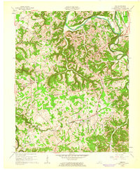
1961 Map of Exie
USGS Topo · Published 1962About this map
The Green River meanders through the northern landscape of Green County, defining a region characterized by deep creek valleys and a dense network of family cemeteries and rural congregations. Small communities like Exie, Thurlow, and Pierce are connected by narrow roads that wind around the local drainage of Little Russell Creek and Greasy Creek. The 1961 revision of this area reveals a transitioning economy, where traditional agriculture is punctuated by numerous gas wells and an abandoned landing strip near Pierce. Genealogists will find an exceptional density of burial sites, including the Sandidge, Whitlock, and Philpot cemeteries, often situated near historic meeting houses like Houks Chapel or Oak Grove Ch. The presence of several schools, such as Russell Creek Sch and Vineyard Sch, alongside a prominent Pipeline, underscores the local infrastructure during the early 1960s.
Find a feature on this map
55 named features on this map. Tap any name to fly to it.
Don’t see what you’re looking for? This feature index may not catch every label — zoom into the map to look around manually.
Map Details
Editions of this 1961 Exie Map
2 editions found
Other maps of this area

1953 · Gradyville
USGS Topo · 1:24,000

1953 · Sulphur Well
USGS Topo · 1:24,000

1953 · Hudgins
USGS Topo · 1:24,000

1953 · Summersville
USGS Topo · 1:24,000

1953 · Exie
USGS Topo · 1:24,000

1953 · Gresham
USGS Topo · 1:24,000

1953 · Center
USGS Topo · 1:24,000

1953 · East Fork
USGS Topo · 1:24,000

1954 · Greensburg
USGS Topo · 1:24,000

1957 · Winchester
USGS Topo · 1:250,000