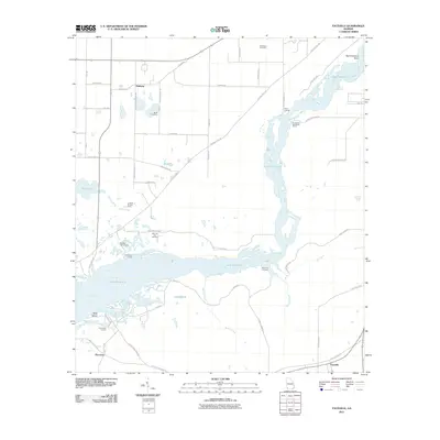
2011 Map of Faceville
USGS Topo · Published 2011About this map
Lake Seminole dominates the central landscape of this Decatur County region, where the Flint River flows through a series of wide basins and narrow channels. Small agricultural and residential clusters such as Bethany and Faceville anchor the surrounding uplands, connected by a network of rural routes like Ten Mile Still Rd and Hutchinson Ferry Rd. The map reveals a deeply rooted local geography marked by family and community landmarks, including the Morning Star Cemetery, Mock Cemetery, and the Breedlove Cemetery. Along the water's edge, numerous access points such as Pattersons Landing, Hales Landing, and Faceville Landing suggest a landscape defined by its relationship to the river system. Notable terrain features like Big Horseshoe Bend and Bass Island further illustrate the intricate shoreline of the reservoir area.
Find a feature on this map
52 named features on this map. Tap any name to fly to it.
Don’t see what you’re looking for? This feature index may not catch every label — zoom into the map to look around manually.
Map Details
Editions of this 2011 Faceville Map
This is the sole edition of this map. No revisions or reprints were ever made.
Other maps of this area

1954 · Desser
USGS Topo · 1:24,000

1954 · Tallahassee
USGS Topo · 1:250,000

1955 · Reynoldsville
USGS Topo · 1:24,000

1955 · Chattahoochee
USGS Topo · 1:24,000

1955 · Bainbridge
USGS Topo · 1:62,500

1955 · Mt Pleasant
USGS Topo · 1:24,000

1956 · Dogtown
USGS Topo · 1:24,000

1959 · Tallahassee
USGS Topo · 1:250,000

1960 · Tallahassee
USGS Topo · 1:250,000
1974 · Bainbridge
USGS Topo · 1:24,000