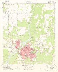
1974 Map of Bainbridge
USGS Topo · Published 1976About this map
The Flint River serves as the central artery for this mid-1970s view of Decatur County, where industrial activity and civic expansion meet at Bainbridge. The landscape is defined by the heavy infrastructure of the Seaboard Coast Line railroad and the Bainbridge corporate boundary, which encompasses a growing network of educational and medical facilities. Significant landmarks include Bainbridge Junior College, Griffin Hospital, and the sprawling Commodore-Decatur Airport to the west.
Find a feature on this map
71 named features on this map. Tap any name to fly to it.
Don’t see what you’re looking for? This feature index may not catch every label — zoom into the map to look around manually.
Map Details
Editions of this 1974 Bainbridge Map
2 editions found
Other maps of this area

1953 · Dothan
USGS Topo · 1:250,000

1954 · Dothan
USGS Topo · 1:250,000

1954 · Tallahassee
USGS Topo · 1:250,000

1955 · Dothan
USGS Topo · 1:250,000

1955 · Bainbridge
USGS Topo · 1:62,500

1955 · Whigham
USGS Topo · 1:62,500

1959 · Tallahassee
USGS Topo · 1:250,000

1960 · Tallahassee
USGS Topo · 1:250,000

1971 · Vada
USGS Topo · 1:24,000

1974 · Boykin
USGS Topo · 1:24,000