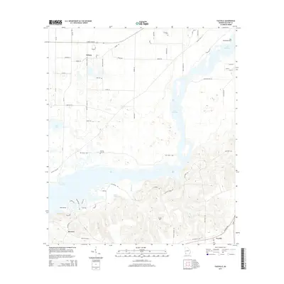
2014 Map of Faceville
USGS Topo · Published 2014About this map
Lake Seminole dominates this portion of Decatur County, where the sprawling reservoir meets the elevations of Curry Hill. The 2014 landscape reveals a mix of established rural settlements and newer lakeside developments, particularly around Faceville and Recovery. For local history and genealogy researchers, the map identifies several distinct family-named burial grounds, including Breedlove Cem in the north and Morning Star Cem near the central waterway. The intricate shoreline of the lake is punctuated by landmarks such as Big Horseshoe Bend and Bass Island, while smaller water bodies like Silver Lake and Peter Pond sit tucked away from the main channel. A network of rural routes, including S Spring Creek Rd and Ten Mile Still Rd, connects these isolated communities and landings through the Georgia pine and bottomlands.
Find a feature on this map
57 named features on this map. Tap any name to fly to it.
Don’t see what you’re looking for? This feature index may not catch every label — zoom into the map to look around manually.
Map Details
Editions of this 2014 Faceville Map
This is the sole edition of this map. No revisions or reprints were ever made.
Other maps of this area

1954 · Desser
USGS Topo · 1:24,000

1954 · Tallahassee
USGS Topo · 1:250,000

1955 · Reynoldsville
USGS Topo · 1:24,000

1955 · Chattahoochee
USGS Topo · 1:24,000

1955 · Bainbridge
USGS Topo · 1:62,500

1955 · Mt Pleasant
USGS Topo · 1:24,000

1956 · Dogtown
USGS Topo · 1:24,000

1959 · Tallahassee
USGS Topo · 1:250,000

1960 · Tallahassee
USGS Topo · 1:250,000
1974 · Bainbridge
USGS Topo · 1:24,000