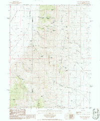
1986 Map of Fagin Mountain
USGS Topo · Published 1986About this map
The Simpson Park Mountains dominate this 1980s landscape, bisected by the county line separating Lander and Eureka. The map reveals an environment defined by its water sources, with numerous named springs such as Crystal Spring, Sheep Corral Spring, and Underwood Spring punctuating the arid terrain. These points of water often correlate with human activity, indicated by several Prospects and Wells scattered through the canyons. Notable high points like Fagin Mountain and Buck Mountain overlook a complex network of drainages, including Moonshine Canyon, Big Canyon, and Cottonwood Canyon. In the northwest corner, the terrain transitions into the expanse of Grass Valley and the Alkali Flat. A solitary Landing Strip situated near the valley floor highlights the necessity of aerial access in this isolated section of the Great Basin.
Find a feature on this map
38 named features on this map. Tap any name to fly to it.
Don’t see what you’re looking for? This feature index may not catch every label — zoom into the map to look around manually.
Map Details
Editions of this 1986 Fagin Mountain Map
This is the sole edition of this map. No revisions or reprints were ever made.
Other maps of this area

1926 · Roberts Mountains
USGS Topo · 1:250,000

1929 · Roberts Mountains
USGS Topo · 1:250,000

1949 · Roberts Creek Mtn
USGS Topo · 1:62,500

1951 · Roberts Creek Mtn
USGS Topo · 1:62,500

1955 · Millett
USGS Topo · 1:250,000

1956 · Bartine Ranch
USGS Topo · 1:62,500

1956 · Walti Hot Springs
USGS Topo · 1:62,500

1956 · Ackerman Canyon
USGS Topo · 1:62,500

1959 · Millett
USGS Topo · 1:250,000

1979 · Simpson Park Mtns
USGS Topo · 1:100,000