
1962 Map of Fair Bluff
USGS Topo · Published 1964About this map
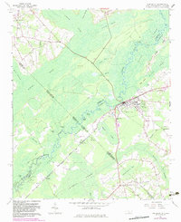
Fair Bluff anchors the landscape where the Atlantic Coast Line Railroad crosses the Lumber River, marking a historic node of commerce along the North Carolina and South Carolina border. The terrain is defined by a complex network of wetlands, including the expansive Ashpole Swamp and Gapway Swamp, which hem in the elevated settlements of Marietta and Causey. These swampy lowlands are dotted with curiously named depressions and water bodies like Deadman Lakes, Sawscalpel Bay, and Devils Elbow, suggesting a landscape where navigation was historically dictated by the winding river and narrow ridges.
Find a feature on this map
58 named features on this map. Tap any name to fly to it.
Don’t see what you’re looking for? This feature index may not catch every label — zoom into the map to look around manually.
Map Details
Editions of this 1962 Fair Bluff Map
2 editions found
Other maps of this area

1943 · Pages Mill
USGS Topo · 1:62,500

1948 · Nichols
USGS Topo · 1:24,000

1949 · Duford
USGS Topo · 1:24,000

1950 · Nichols
USGS Topo · 1:24,000

1953 · Chadbourn
USGS Topo · 1:62,500

1953 · Florence
USGS Topo · 1:250,000

1954 · Florence
USGS Topo · 1:250,000

1962 · Fairmont
USGS Topo · 1:24,000

1962 · Lake View
USGS Topo · 1:24,000
1962 · Tabor City West
USGS Topo · 1:24,000