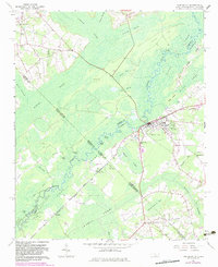
1962 Map of Fair Bluff
USGS Topo · Published 1983About this map
The Lumber River and Ashpole Swamp dominate this landscape on the border of North Carolina and South Carolina, where water defines the layout of early settlements and agriculture. In the town of Fair Bluff, the community is centered near the riverbanks and the S C L railroad, while smaller rural nodes like Marietta and Causey are connected by roads that skirt the expansive wetlands of Gapway Swamp. Genealogists will find a wealth of family-related landmarks, from the Marietta Cem and Meares Cem to local congregations at Turner Chapel and Spring Branch Ch. The map reveals a transition in land use, featuring an Old Railroad Grade and numerous bays and bluffs, such as Watermelon Bluff and Buck Head Bay, illustrating how the swampy terrain dictated the paths of transport and industry in the mid-20th century.
Find a feature on this map
55 named features on this map. Tap any name to fly to it.
Don’t see what you’re looking for? This feature index may not catch every label — zoom into the map to look around manually.
Map Details
Editions of this 1962 Fair Bluff Map
2 editions found
Other maps of this area

1943 · Pages Mill
USGS Topo · 1:62,500

1948 · Nichols
USGS Topo · 1:24,000

1949 · Duford
USGS Topo · 1:24,000

1950 · Nichols
USGS Topo · 1:24,000

1953 · Chadbourn
USGS Topo · 1:62,500

1953 · Florence
USGS Topo · 1:250,000

1954 · Florence
USGS Topo · 1:250,000

1962 · Fair Bluff
USGS Topo · 1:24,000

1962 · Fairmont
USGS Topo · 1:24,000

1962 · Lake View
USGS Topo · 1:24,000