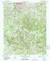
1951 Map of Fair Grove
USGS Topo · Published 1987About this map
The industrial and agricultural corridor of the Piedmont is anchored here by the southern edge of Thomasville, where the presence of the Mills Home and Holly Hill Cem mark the community's early development. Moving south, the landscape transitions into a network of small crossroad settlements and farmsteads such as Johnsontown, Fair Grove, and Gordontown. The local economy of the mid-20th century is evidenced by infrastructure like the Hiatt Airport and the Thomasville and Denton railroad line, which served the various stations and mills dotting the countryside.
Find a feature on this map
33 named features on this map. Tap any name to fly to it.
Don’t see what you’re looking for? This feature index may not catch every label — zoom into the map to look around manually.
Map Details
Editions of this 1951 Fair Grove Map
4 editions found
Other maps of this area

1949 · Denton NW
USGS Topo · 1:24,000

1949 · Eller
USGS Topo · 1:24,000

1949 · High Point West
USGS Topo · 1:24,000

1950 · High Point East
USGS Topo · 1:24,000

1950 · Lexington East
USGS Topo · 1:24,000

1951 · Lexington East
USGS Topo · 1:24,000

1951 · High Point East
USGS Topo · 1:24,000

1951 · Fair Grove
USGS Topo · 1:24,000

1953 · Raleigh
USGS Topo · 1:250,000

1953 · Charlotte
USGS Topo · 1:250,000