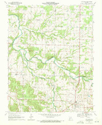
1970 Map of Fair Grove
USGS Topo · Published 1971About this map
Fair Grove and its surrounding countryside are defined by the winding course of the Pomme De Terre River as it passes through northern Greene County and into Dallas and Polk counties. This 1970 snapshot of the landscape shows a network of rural settlements like Rock Prairie, Tin Town, and Fruitland, connected by section-line roads and field boundaries. The area is punctuated by notable topographic rises such as Goodnight Knob, Henley Knob, and Lucas Knob, which offer vertical contrast to the river valley. Genealogists and local historians will find several burial grounds and community centers including New Life Cemetery, Mallard Cemetery, and Glover Cemetery. Spiritual life is anchored by country churches like High Prairie Church and Union Grove Church, while the local economy is subtly marked by a Quarry and Roadside Park near the intersection of major thoroughfares.
Find a feature on this map
29 named features on this map. Tap any name to fly to it.
Don’t see what you’re looking for? This feature index may not catch every label — zoom into the map to look around manually.
Map Details
Editions of this 1970 Fair Grove Map
2 editions found
Other maps of this area

1884 · Springfield
USGS Topo · 1:125,000

1884 · Bolivar
USGS Topo · 1:125,000

1886 · Springfield
USGS Topo · 1:125,000

1892 · Bolivar
USGS Topo · 1:125,000

1946 · Bassville
USGS Topo · 1:24,000

1947 · Strafford
USGS Topo · 1:62,500

1948 · Bassville
USGS Topo · 1:24,000

1948 · Ebenezer
USGS Topo · 1:24,000

1948 · Strafford
USGS Topo · 1:62,500

1954 · Springfield
USGS Topo · 1:250,000