
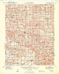
1948 Map of Strafford
USGS Topo · Published 1948About this map
The St Louis San Francisco railroad cuts a straight path through the southern Missouri countryside, anchoring the town of Strafford at the height of the post-war era. This landscape is a complex network of rural community hubs, defined by its numerous small schoolhouses like Hasten Sch and Elkland Sch, alongside country churches such as Missions Chapel and Union Grove Ch. These sites provide critical waypoints for genealogists tracing family roots across the Ozark Plateau.
Find a feature on this map
79 named features on this map. Tap any name to fly to it.
Don’t see what you’re looking for? This feature index may not catch every label — zoom into the map to look around manually.
Map Details
Editions of this 1948 Strafford Map
2 editions found
Other maps of this area

1884 · Springfield
USGS Topo · 1:125,000

1884 · Bolivar
USGS Topo · 1:125,000

1886 · Springfield
USGS Topo · 1:125,000

1892 · Bolivar
USGS Topo · 1:125,000

1935 · Springfield
USGS Topo · 1:24,000

1937 · Galloway
USGS Topo · 1:24,000

1937 · Ozark
USGS Topo · 1:48,000

1939 · Fordland
USGS Topo · 1:62,500

1939 · Long Lane
USGS Topo · 1:62,500

1942 · Fordland
USGS Topo · 1:62,500