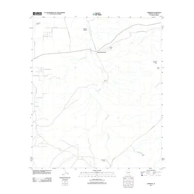
2012 Map of Fairbank
USGS Topo · Published 2012About this map
Fairbank (historical) serves as the focal point of this 2012 survey, situated at the confluence where Walnut Gulch meets the northward-flowing San Pedro River. The landscape is defined by the riparian corridors of the San Pedro and its western tributary, the Babocomari River, which cut through the arid terrain of Cochise County. This area represents a crossroads of Arizona ranching history and early transportation, anchored by large holdings like Boquillas Ranch and Lindsey Ranch. The map captures a modern view of these long-established desert spaces, showing the intersection of historic rail points like Benson Junction with newer infrastructure such as Four Pillars Airport. Elevations rise to the east toward The Three Brothers Hills and Mays Hills, while local road names like W Schieffelin Monument Rd and E Headless Man Trl provide distinctive clues for local historians tracing the heritage of the Tombstone-Fairbank corridor.
Find a feature on this map
29 named features on this map. Tap any name to fly to it.
Don’t see what you’re looking for? This feature index may not catch every label — zoom into the map to look around manually.
Map Details
Editions of this 2012 Fairbank Map
This is the sole edition of this map. No revisions or reprints were ever made.
Other maps of this area

1915 · Benson
USGS Topo · 1:125,000

1922 · St. David
USGS Topo · 1:62,500

1926 · Whetstone
USGS Topo · 1:62,500

1932 · Fairbank
USGS Topo · 1:62,500

1938 · Huachuca
USGS Topo · 1:62,500

1943 · Benson
USGS Topo · 1:125,000

1948 · Fort Huachuca NE
USGS Topo · 1:24,000
1948 · Fort Huachuca
USGS Topo · 1:24,000
1948 · Fort Huachuca
USGS Topo · 1:62,500

1952 · Tombstone SE
USGS Topo · 1:24,000