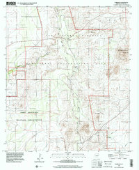
1996 Map of Fairbank
USGS Topo · Published 2002About this map
Fairbank and Charleston serve as primary focal points along the San Pedro River in this survey based on late 20th-century planimetry. The landscape reveals a transition from the early mining and ranching era to modern conservation efforts, highlighted by the San Pedro Riparian National Conservation Area. Evidence of historical industry is visible through the Charleston Lead Mine and various prospects scattered near Graveyard Gulch.
Find a feature on this map
25 named features on this map. Tap any name to fly to it.
Don’t see what you’re looking for? This feature index may not catch every label — zoom into the map to look around manually.
Map Details
Editions of this 1996 Fairbank Map
This is the sole edition of this map. No revisions or reprints were ever made.
Other maps of this area

1915 · Benson
USGS Topo · 1:125,000

1922 · St. David
USGS Topo · 1:62,500

1926 · Whetstone
USGS Topo · 1:62,500

1932 · Fairbank
USGS Topo · 1:62,500

1938 · Huachuca
USGS Topo · 1:62,500

1943 · Benson
USGS Topo · 1:125,000

1948 · Fort Huachuca NE
USGS Topo · 1:24,000
1948 · Fort Huachuca
USGS Topo · 1:24,000
1948 · Fort Huachuca
USGS Topo · 1:62,500

1952 · Tombstone SE
USGS Topo · 1:24,000