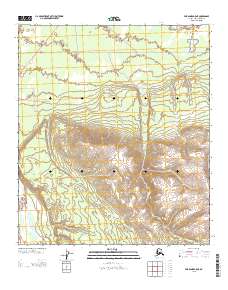
2013 Map of Fairbanks A-5 NE
USGS Topo · Published 2013About this map
High interior terrain and essential transport corridors define this portion of the Alaska-Denali Borough. The Parks Hwy cuts through the northwest corner, while the historic Rex Trl stretches across the northern sections, marking a vital route for overland travel in this demanding environment. The landscape is deeply carved by water, most notably by the south-flowing Windy Cr and the larger Nenana River along the western edge, which is joined by June Cr and Bear Cr. These drainage patterns indicate a high-elevation watershed where small tributaries consolidate into significant river systems. This map captures the intersection of modern infrastructure and traditional trails against a backdrop of steep elevation changes and complex hydrology, serving as a primary record of the region’s topography in the early 21st century.
Find a feature on this map
9 named features on this map. Tap any name to fly to it.
Don’t see what you’re looking for? This feature index may not catch every label — zoom into the map to look around manually.
Map Details
Editions of this 2013 Fairbanks A-5 NE Map
This is the sole edition of this map. No revisions or reprints were ever made.
Other maps of this area

1949 · Fairbanks B-5
USGS Topo · 1:63,360

1949 · Fairbanks B-4
USGS Topo · 1:63,360

1950 · Fairbanks
USGS Topo · 1:250,000

1950 · Fairbanks A-5
USGS Topo · 1:63,360

1950 · Fairbanks A-4
USGS Topo · 1:63,360

1950 · Fairbanks B-5
USGS Topo · 1:63,360

1951 · Fairbanks B-5
USGS Topo · 1:63,360

1951 · Fairbanks
USGS Topo · 1:250,000

1951 · Fairbanks A-5
USGS Topo · 1:63,360
1952 · Fairbanks A-4
USGS Topo · 1:63,360