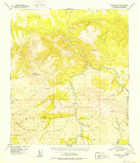
1952 Map of Fairbanks A-4
USGS Topo · Published 1952About this map
The Tatlani Ka River carves through the landscape of the Fourth Judicial Division, defining a region where early 1950s mineral exploration and remote access routes predominate. The presence of the Liberty Bell Mine and a Placer Mine near Fourth of July Creek highlights the era's focus on resource extraction in this part of the Alaska interior. The terrain is marked by significant elevations like Rex Dome and VABM Coal 4165, while isolated Airstrip locations and several Cabin markers indicate the sparse, localized nature of human activity.
Find a feature on this map
35 named features on this map. Tap any name to fly to it.
Don’t see what you’re looking for? This feature index may not catch every label — zoom into the map to look around manually.
Map Details
Editions of this 1952 Fairbanks A-4 Map
2 editions found
Other maps of this area

1949 · Fairbanks B-5
USGS Topo · 1:63,360

1949 · Fairbanks B-4
USGS Topo · 1:63,360

1949 · Fairbanks B-3
USGS Topo · 1:63,360

1950 · Fairbanks
USGS Topo · 1:250,000

1950 · Fairbanks A-5
USGS Topo · 1:63,360

1950 · Healy D-4
USGS Topo · 1:63,360

1950 · Fairbanks A-4
USGS Topo · 1:63,360

1950 · Fairbanks A-3
USGS Topo · 1:63,360

1950 · Healy D-3
USGS Topo · 1:63,360

1950 · Fairbanks B-5
USGS Topo · 1:63,360