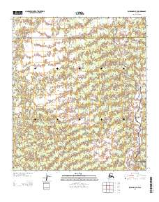
2013 Map of Fairbanks B-5 SW
USGS Topo · Published 2013About this map
The Nenana River dominates the eastern landscape of this interior Alaska territory, where the boundary between Yukon-Koyukuk and Denali is established. The river's influence on the terrain is evident through the complex waterways of Seventeenmile Slough and Lost Slough, which branch away from the main channel into the surrounding lowlands. Human presence in this environment is marked by a sparse network of specialized transit routes, including Bush Rd, Nenana Rd, and the seasonally named Sled Rd. These thoroughfares suggest a landscape utilized for local transport and access to the river's edge, reflecting the remote nature of the region's infrastructure in the early twenty-first century.
Find a feature on this map
7 named features on this map. Tap any name to fly to it.
Don’t see what you’re looking for? This feature index may not catch every label — zoom into the map to look around manually.
Map Details
Editions of this 2013 Fairbanks B-5 SW Map
This is the sole edition of this map. No revisions or reprints were ever made.
Other maps of this area

1949 · Fairbanks B-5
USGS Topo · 1:63,360

1950 · Fairbanks
USGS Topo · 1:250,000

1950 · Fairbanks A-5
USGS Topo · 1:63,360

1950 · Fairbanks B-5
USGS Topo · 1:63,360

1951 · Fairbanks B-5
USGS Topo · 1:63,360

1951 · Fairbanks
USGS Topo · 1:250,000

1951 · Fairbanks A-5
USGS Topo · 1:63,360

1952 · Fairbanks A-6
USGS Topo · 1:63,360

1952 · Fairbanks
USGS Topo · 1:250,000
1953 · Fairbanks B-6
USGS Topo · 1:63,360