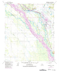
1950 Map of Fairbanks C-1
USGS Topo · Published 1992About this map
Tanana River dominates this interior Alaska landscape, weaving a complex network of braided channels and seasonal waterways through the heart of the Fort Wainwright Military Reservation. The map details a landscape shaped by mid-century defense and infrastructure, most notably the expansive Eielson Air Force Base situated between Garrison Slough and French Creek. The transport corridor is defined by the Richardson Highway, which runs parallel to modern energy lifelines including The Alaska Pipeline and a dedicated Military Pipeline. Notable terrain features like Moose Creek Bluff overlook the confluence of the Chena Slough and the main river, while numerous smaller waterways such as Salchaket Slough and Piledriver Slough illustrate the dynamic alluvial environment. This 1950s record, updated with 1970s revisions, captures the strategic buildup and resource transit points that defined this region's post-war development.
Find a feature on this map
23 named features on this map. Tap any name to fly to it.
Don’t see what you’re looking for? This feature index may not catch every label — zoom into the map to look around manually.
Map Details
Editions of this 1950 Fairbanks C-1 Map
4 editions found
Other maps of this area

1949 · Fairbanks D-1
USGS Topo · 1:62,500

1949 · Fairbanks D-2
USGS Topo · 1:62,500

1949 · Big Delta B-6
USGS Topo · 1:63,360

1949 · Fairbanks C-1
USGS Topo · 1:63,360

1949 · Big Delta C-6
USGS Topo · 1:63,360

1949 · Fairbanks C-2
USGS Topo · 1:63,360

1950 · Fairbanks
USGS Topo · 1:250,000

1950 · Big Delta
USGS Topo · 1:250,000

1950 · Big Delta D-6
USGS Topo · 1:63,360

1950 · Fairbanks C-1
USGS Topo · 1:63,360