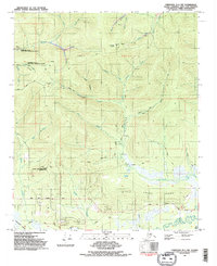
1992 Map of Fairbanks D-1 NW
USGS Topo · Published 1992About this map
Scientific and industrial infrastructure punctuates this subarctic landscape north of Fairbanks, where the Fairbanks No. 2 NASA Data Aquisition Facility and the Eielson Alaska Long Period Array Research Site represent significant Cold War-era research and telemetry installations. The terrain is defined by the high point of Gilmore Dome and the winding course of the Little Chena River, which flows through the southern portion of the sheet. Modern engineering is visible in the alignment of the Trans-Alaska Pipeline and the arterial Chena Hot Springs Road.
Find a feature on this map
39 named features on this map. Tap any name to fly to it.
Don’t see what you’re looking for? This feature index may not catch every label — zoom into the map to look around manually.
Map Details
Editions of this 1992 Fairbanks D-1 NW Map
2 editions found
Other maps of this area

1945 · Livengood
USGS Topo · 1:250,000

1949 · Fairbanks D-1
USGS Topo · 1:62,500

1949 · Fairbanks D-2
USGS Topo · 1:62,500

1950 · Fairbanks
USGS Topo · 1:250,000

1951 · Fairbanks
USGS Topo · 1:250,000

1951 · Livengood
USGS Topo · 1:250,000

1952 · Fairbanks D-2
USGS Topo · 1:63,360
1952 · Fairbanks D-1
USGS Topo · 1:63,360

1952 · Fairbanks
USGS Topo · 1:250,000

1952 · Livengood A-2
USGS Topo · 1:63,360