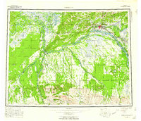
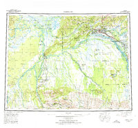
1952 Map of Fairbanks
USGS Topo · Published 1960About this map
Fairbanks serves as the regional hub in this mid-century survey, surrounded by the expanding infrastructure of Interior Alaska. The territorial landscape is defined by the heavy presence of The Alaska Railroad, which links settlements like Nenana and Dunbar through the valley of the Tanana River. Strategic development is evident at Ladd AFB and Eielson Air Force Base, while the Univ of Alaska anchors the academic community near the city center. South of the main river corridor, the terrain transitions into a massive Bombing and Gunnery Range and the foothills of the Japan Hills. Local industry is reflected in a Placer Mine near Rex Dome, while transport relies on both modern rails and traditional routes like the Sled Road near Tolovana. The map illustrates the complex overlay of military, educational, and resource-extraction interests during a pivotal era of growth.
Find a feature on this map
67 named features on this map. Tap any name to fly to it.
Don’t see what you’re looking for? This feature index may not catch every label — zoom into the map to look around manually.
Map Details
Editions of this 1952 Fairbanks Map
6 editions found

Other maps of this area

1945 · Livengood
USGS Topo · 1:250,000

1948 · Kantishna River
USGS Topo · 1:250,000

1949 · Fairbanks D-1
USGS Topo · 1:62,500

1949 · Fairbanks D-2
USGS Topo · 1:62,500

1949 · Big Delta B-6
USGS Topo · 1:63,360

1949 · Fairbanks B-5
USGS Topo · 1:63,360

1949 · Fairbanks C-1
USGS Topo · 1:63,360

1949 · Fairbanks D-3
USGS Topo · 1:63,360

1949 · Big Delta C-6
USGS Topo · 1:63,360

1949 · Fairbanks D-4
USGS Topo · 1:63,360