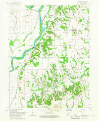
1966 Map of Fairbanks
USGS Topo · Published 1967About this map
The Wabash River serves as the dividing line between Clark County, Illinois and Sullivan County, Indiana in this mid-1960s topographical study. The settlement of Fairbanks sits on the Indiana side, surrounded by a high density of family and community burial grounds including the Walnut Prairie Cem, DeBaun Cem, and Riggs-Ernest Cem. This landscape reveals a diverse local economy where agriculture meets energy and industry, evidenced by an extensive southern Oil Field and a dedicated Industrial Railroad Road serving the riverfront infrastructure near the Powerplant. Significant prehistoric sites are noted along the bluffs, including several Indian Mounds and the prominent Indian Mound overlooking Prairie Creek. The map also captures several local landmarks like Dodds Bridge crossing Turman Creek, and rural houses of worship such as Brick Ch and Union Chapel.
Find a feature on this map
36 named features on this map. Tap any name to fly to it.
Don’t see what you’re looking for? This feature index may not catch every label — zoom into the map to look around manually.
Map Details
Editions of this 1966 Fairbanks Map
2 editions found
Other maps of this area

1932 · Marshall
USGS Topo · 1:62,500

1937 · Marshall
USGS Topo · 1:62,500

1940 · Pimento
USGS Topo · 1:24,000

1942 · Fairbanks
USGS Topo · 1:24,000

1942 · Shelburn
USGS Topo · 1:24,000

1942 · Hutton
USGS Topo · 1:24,000

1943 · Merom
USGS Topo · 1:24,000

1943 · Sullivan
USGS Topo · 1:24,000

1952 · Fairbanks
USGS Topo · 1:24,000

1952 · Shelburn
USGS Topo · 1:24,000