
1951 Map of Fairburn SE
USGS Topo · Published 1951About this map
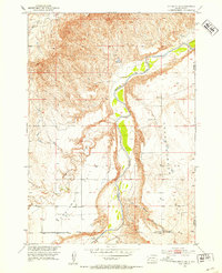
The Cheyenne River winds through this mid-century landscape where Custer and Shannon Counties meet, creating a deep corridor flanked by elevated plains. This 1951 field-checked survey reveals the dispersed rural infrastructure of the Missouri River Basin development program, specifically identifying isolated educational outposts like Harrison Flat Sch and Greives Sch. The topography is defined by significant landmarks including the broad expanse of Harrison Flat and the prominent Table, which sit above the winding drainage of Cottonwood Creek and Spring Canyon. Along the eastern edge, the Pine Ridge Indian Reservation Boundary marks a clear administrative transition, while the northern reaches are carved by French Creek and its South Fork. These natural drainage patterns dictate the placement of early roads and small settlements across the high prairie.
Find a feature on this map
12 named features on this map. Tap any name to fly to it.
Don’t see what you’re looking for? This feature index may not catch every label — zoom into the map to look around manually.
Map Details
Editions of this 1951 Fairburn SE Map
2 editions found
Other maps of this area

1894 · Hermosa
USGS Topo · 1:125,000

1896 · Oelrichs
USGS Topo · 1:125,000

1900 · Oelrichs
USGS Topo · 1:125,000

1901 · Hermosa
USGS Topo · 1:125,000

1951 · Red Shirt
USGS Topo · 1:24,000

1951 · Willow Creek NW
USGS Topo · 1:24,000

1951 · Red Shirt SW
USGS Topo · 1:24,000

1951 · Smithwick NE
USGS Topo · 1:24,000

1951 · Smithwick NW
USGS Topo · 1:24,000

1955 · Hot Springs
USGS Topo · 1:250,000