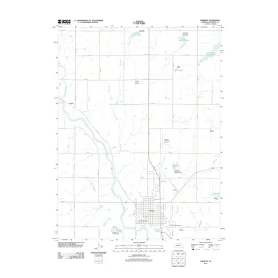
2011 Map of Fairbury
USGS Topo · Published 2011About this map
The Little Blue River cuts a wide, meandering path through Jefferson County, anchoring the settlement of Fairbury. This 2011 survey reveals a landscape balanced between municipal expansion and water management, characterized by a series of flood control structures such as Cub Creek Reservoir 17-B and the Rudolph E Glaeseman Detention Dam. The gridded streets of the city center give way to the Jefferson County Fairground and the Fairbury Municipal Airport, while the surrounding rural areas are dotted with local history markers including Richland Center Cemetery and Grandy Cemetery. The presence of Crystal Springs Campground south of town highlights the area's recreational geography. Small drainages like Whisky Run and Brauner Creek feed into the main river valley, illustrating the complex hydrology essential to this agricultural region. To the northwest, the small settlement of Hedrix sits near the confluence of Little Sandy Creek, marking the intersection of established road networks and natural waterways.
Find a feature on this map
60 named features on this map. Tap any name to fly to it.
Don’t see what you’re looking for? This feature index may not catch every label — zoom into the map to look around manually.
Map Details
Editions of this 2011 Fairbury Map
This is the sole edition of this map. No revisions or reprints were ever made.
Other maps of this area

1955 · Lincoln
USGS Topo · 1:250,000

1957 · Lincoln
USGS Topo · 1:250,000

1958 · Lincoln
USGS Topo · 1:250,000

1960 · Fairbury SW
USGS Topo · 1:24,000

1960 · Reynolds
USGS Topo · 1:24,000

1960 · Western SW
USGS Topo · 1:24,000

1960 · Fairbury
USGS Topo · 1:24,000
1960 · Gladstone
USGS Topo · 1:24,000

1960 · Daykin
USGS Topo · 1:24,000

1961 · Western SE
USGS Topo · 1:24,000