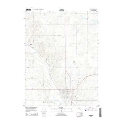
2014 Map of Fairbury
USGS Topo · Published 2014About this map
The Little Blue River cuts a wide alluvial valley diagonally across this Jefferson County landscape, anchoring the settlement of Fairbury at the junction of Us-136 and Ne-15. This 2014 survey captures the community's established grid, extending from the central business district near 7th ST and 8th ST out to the Fairbury Municipal Airport and the industrial corridors along Industrial Ave. The surrounding prairie is defined by a dense network of sectional roads and water management features, including numerous reservoirs such as Cub Creek Reservoir 17-B and Davis Reservoir. For genealogists and local historians, the map provides precise locations for several rural burying grounds, including Richland Center Cem to the north and Grandy Cem to the east, while the village of Hedrix sits tucked near the confluence of Little Sandy Creek and the river valley.
Find a feature on this map
50 named features on this map. Tap any name to fly to it.
Don’t see what you’re looking for? This feature index may not catch every label — zoom into the map to look around manually.
Map Details
Editions of this 2014 Fairbury Map
This is the sole edition of this map. No revisions or reprints were ever made.
Other maps of this area

1955 · Lincoln
USGS Topo · 1:250,000

1957 · Lincoln
USGS Topo · 1:250,000

1958 · Lincoln
USGS Topo · 1:250,000

1960 · Fairbury SW
USGS Topo · 1:24,000

1960 · Reynolds
USGS Topo · 1:24,000

1960 · Western SW
USGS Topo · 1:24,000

1960 · Fairbury
USGS Topo · 1:24,000
1960 · Gladstone
USGS Topo · 1:24,000

1960 · Daykin
USGS Topo · 1:24,000

1961 · Western SE
USGS Topo · 1:24,000