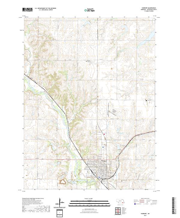
2021 Map of Fairbury
USGS Topo · Published 2021About this map
Fairbury serves as the focal point of this Jefferson County survey, situated along the north bank of the Little Blue River. The town's grid is dominated by the Jefferson County Courthouse and a series of numbered streets, extending southward to the river's edge. The surrounding landscape is defined by the carved drainage basins of Whisky Run and Little Sandy Creek, which feed into the main river channel from the north and west. Several agricultural reservoirs, including Cub Cr Reservoir 17-B, Davis Reservoir, and Glaeseman Reservoir, are scattered across the high ground, reflecting modern water management in this prairie region.
Find a feature on this map
72 named features on this map. Tap any name to fly to it.
Don’t see what you’re looking for? This feature index may not catch every label — zoom into the map to look around manually.
Map Details
Editions of this 2021 Fairbury Map
This is the sole edition of this map. No revisions or reprints were ever made.
Other maps of this area

1955 · Lincoln
USGS Topo · 1:250,000

1957 · Lincoln
USGS Topo · 1:250,000

1958 · Lincoln
USGS Topo · 1:250,000

1960 · Fairbury SW
USGS Topo · 1:24,000

1960 · Reynolds
USGS Topo · 1:24,000

1960 · Western SW
USGS Topo · 1:24,000

1960 · Fairbury
USGS Topo · 1:24,000
1960 · Gladstone
USGS Topo · 1:24,000

1960 · Daykin
USGS Topo · 1:24,000

1961 · Western SE
USGS Topo · 1:24,000