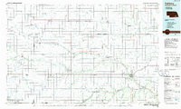
1985 Map of Fairbury
USGS Topo · Published 1985About this map
Fairbury and the surrounding plains of southern Nebraska and northern Kansas are depicted in this mid-1980s planimetric study. The landscape is defined by a dense grid of agricultural section lines and small rail-oriented communities like Hebron, Deshler, and Bruning. The winding path of the Little Blue River provides a natural break in the geometric township layout, accompanied by smaller tributaries such as Sandy Creek and Turkey Creek.
Find a feature on this map
63 named features on this map. Tap any name to fly to it.
Don’t see what you’re looking for? This feature index may not catch every label — zoom into the map to look around manually.
Map Details
Editions of this 1985 Fairbury Map
2 editions found
Other maps of this area

1889 · Marysville
USGS Topo · 1:125,000

1892 · Concordia
USGS Topo · 1:125,000

1893 · Washington
USGS Topo · 1:125,000

1894 · Mankato
USGS Topo · 1:125,000

1894 · Marysville
USGS Topo · 1:125,000

1897 · Lincoln
USGS Topo · 1:125,000

1898 · York
USGS Topo · 1:125,000

1898 · Superior
USGS Topo · 1:125,000

1898 · Hebron
USGS Topo · 1:125,000

1898 · Grand Island
USGS Topo · 1:125,000