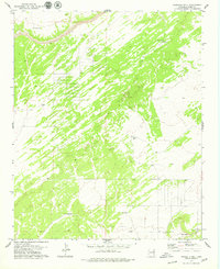
1979 Map of Fairchild Well
USGS Topo · Published 1979About this map
Petroglyphs located in the southeastern corner of the quadrangle provide a window into the cultural history of this high-altitude landscape in Apache County. This 1970s survey captures a sparse ranching and grazing territory where survival was dictated by the availability of water. The presence of numerous designated water sources, including the namesake Fairchild Well, Bar-N Well, and Mesa Well, highlights the critical infrastructure required for livestock management in this arid region. The drainage of Hardscrabble Wash cuts across the southern portion of the sheet, while a complex network of fence and field lines, visible from aerial photography, reveals the methodical division of the land during this era. This topographic record preserves the locations of isolated Water Tank sites and boundary markers essential for navigation and property identification in the vast desert expanses of Arizona.
Find a feature on this map
8 named features on this map. Tap any name to fly to it.
Don’t see what you’re looking for? This feature index may not catch every label — zoom into the map to look around manually.
Map Details
Editions of this 1979 Fairchild Well Map
2 editions found
Other maps of this area

1886 · St Johns
USGS Topo · 1:250,000

1886 · Fort Defiance
USGS Topo · 1:250,000

1892 · Fort Defiance
USGS Topo · 1:250,000

1892 · St Johns
USGS Topo · 1:250,000

1954 · Saint Johns
USGS Topo · 1:250,000

1954 · Gallup
USGS Topo · 1:250,000

1957 · Saint Johns
USGS Topo · 1:250,000

1958 · Gallup
USGS Topo · 1:250,000

1958 · Saint Johns
USGS Topo · 1:250,000

1959 · Gallup
USGS Topo · 1:250,000