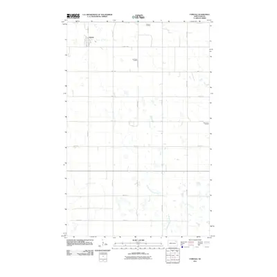
2011 Map of Fairdale
USGS Topo · Published 2011About this map
Fairdale anchors this section of Walsh County, showing its grid of residential streets including Main St and Merl St. The surrounding landscape is defined by the agricultural section lines of the North Dakota prairie, punctuated by several historic burial sites that speak to the area's early 20th-century settlement. These include the Ohnstad Cemetery in the north and the Old Aadalen Cemetery located centrally along 114th Ave NE. The Middle Branch Forest River meanders through the southern half of the map, carving a natural path through the otherwise rigid geometry of county roads like County Hwy 9 and County Rd 22. This survey documents a quiet rural township where the legacy of pioneer families is preserved in name across landmarks like the West Adams Cemetery.
Find a feature on this map
21 named features on this map. Tap any name to fly to it.
Don’t see what you’re looking for? This feature index may not catch every label — zoom into the map to look around manually.
Map Details
Editions of this 2011 Fairdale Map
This is the sole edition of this map. No revisions or reprints were ever made.
Other maps of this area

1953 · Devils Lake
USGS Topo · 1:250,000

1956 · Devils Lake
USGS Topo · 1:250,000

1972 · Nekoma
USGS Topo · 1:24,000

1972 · Osnabrock SW
USGS Topo · 1:24,000

1972 · Adams
USGS Topo · 1:24,000

1972 · Adams SW
USGS Topo · 1:24,000

1972 · Fairdale
USGS Topo · 1:24,000

1972 · Edmore NE
USGS Topo · 1:24,000

1972 · Lawton
USGS Topo · 1:24,000
1972 · Adams SE
USGS Topo · 1:24,000