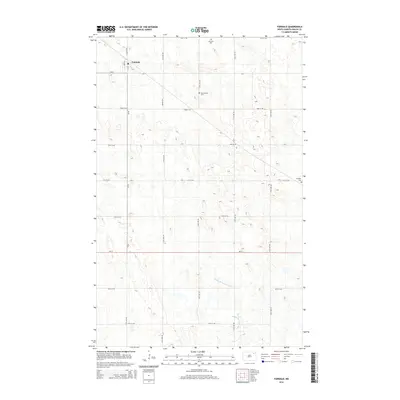
2014 Map of Fairdale
USGS Topo · Published 2014About this map
Fairdale sits at the intersection of CR-22 and CR-9 in this Walsh County landscape. The area is defined by a rigorous grid of section lines and gravel roads, including 75th St NE and 112th Ave NE, which reflect the region's enduring agricultural organization. Family and community heritage is preserved across the township in several local burial sites, such as Ohnstad Cem, Old Aadalen Cem, and W Adams Cem. The terrain is characterized by the meandering path of the Middle Br Forest River, which cuts through the prairie in the southern half of the quadrangle. Transportation routes like ND-17 and the Prairie Trl connect this rural pocket to the broader North Dakota plains, illustrating the intersection of modern state highways and local agricultural access roads.
Find a feature on this map
22 named features on this map. Tap any name to fly to it.
Don’t see what you’re looking for? This feature index may not catch every label — zoom into the map to look around manually.
Map Details
Editions of this 2014 Fairdale Map
This is the sole edition of this map. No revisions or reprints were ever made.
Other maps of this area

1953 · Devils Lake
USGS Topo · 1:250,000

1956 · Devils Lake
USGS Topo · 1:250,000

1972 · Nekoma
USGS Topo · 1:24,000

1972 · Osnabrock SW
USGS Topo · 1:24,000

1972 · Adams
USGS Topo · 1:24,000

1972 · Adams SW
USGS Topo · 1:24,000

1972 · Fairdale
USGS Topo · 1:24,000

1972 · Edmore NE
USGS Topo · 1:24,000

1972 · Lawton
USGS Topo · 1:24,000
1972 · Adams SE
USGS Topo · 1:24,000