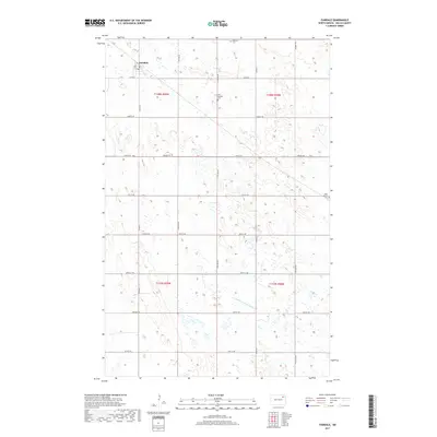
2017 Map of Fairdale
USGS Topo · Published 2017About this map
The small community of Fairdale serves as the focal point for this section of Walsh County, situated in a landscape characterized by a systematic grid of section lines and water management. Local family history is centered on several rural burial grounds, including Ohnstad Cem in the north and the Old Aadalen Cem located along the township boundary. The agricultural character of the region is evident in the network of county and township roads, such as Co Hwy 9 and the recurring Prairie Trl, which navigate the numerous small potholes and wetlands common to this part of North Dakota. In the southern half of the map, the headwaters of the Middle Br Forest River begin to emerge, providing a slight variance in the otherwise rectilinear topography of the surrounding prairies.
Find a feature on this map
18 named features on this map. Tap any name to fly to it.
Don’t see what you’re looking for? This feature index may not catch every label — zoom into the map to look around manually.
Map Details
Editions of this 2017 Fairdale Map
This is the sole edition of this map. No revisions or reprints were ever made.
Other maps of this area

1953 · Devils Lake
USGS Topo · 1:250,000

1956 · Devils Lake
USGS Topo · 1:250,000

1972 · Nekoma
USGS Topo · 1:24,000

1972 · Osnabrock SW
USGS Topo · 1:24,000

1972 · Adams
USGS Topo · 1:24,000

1972 · Adams SW
USGS Topo · 1:24,000

1972 · Fairdale
USGS Topo · 1:24,000

1972 · Edmore NE
USGS Topo · 1:24,000

1972 · Lawton
USGS Topo · 1:24,000
1972 · Adams SE
USGS Topo · 1:24,000