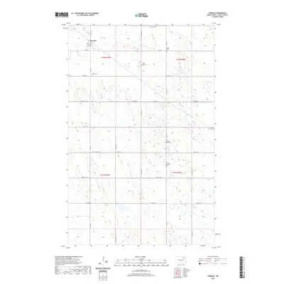
2020 Map of Fairdale
USGS Topo · Published 2020About this map
Fairdale anchors this Walsh County landscape, situated at the intersection of Co Hwy 9 and Co Rd 22. This agricultural region is defined by a grid of rural sections, where legacy family names and religious heritage are preserved through numerous burial grounds. The map reveals a dense concentration of local history markers, including the Aadalen Cem and Old Aadalen Cem to the north, while the Gustavus Adolphus Cem and German Lutheran Cem stand further south. The presence of the Hosna Burial Site and West Adams Cem reflects the deep-rooted settlement patterns of the township's early residents. Transportation across these prairie lands relies on a network of straight-line roads like Prairie Trl and various numbered avenues that cross the undulating plains of northeastern North Dakota.
Find a feature on this map
28 named features on this map. Tap any name to fly to it.
Don’t see what you’re looking for? This feature index may not catch every label — zoom into the map to look around manually.
Map Details
Editions of this 2020 Fairdale Map
This is the sole edition of this map. No revisions or reprints were ever made.
Other maps of this area

1953 · Devils Lake
USGS Topo · 1:250,000

1956 · Devils Lake
USGS Topo · 1:250,000

1972 · Nekoma
USGS Topo · 1:24,000

1972 · Osnabrock SW
USGS Topo · 1:24,000

1972 · Adams
USGS Topo · 1:24,000

1972 · Adams SW
USGS Topo · 1:24,000

1972 · Fairdale
USGS Topo · 1:24,000

1972 · Edmore NE
USGS Topo · 1:24,000

1972 · Lawton
USGS Topo · 1:24,000
1972 · Adams SE
USGS Topo · 1:24,000